Written by David Wilson and Photos by Christopher Kimmel / Alpine Edge Photography
When I first heard of Akshayuk Pass twelve years ago and saw photos of Mt. Thor and Mt. Asgard, I could not believe that this place was real; I needed to go. The Pass quickly became one of the top items on my bucket list, and a frequent visitor to my wandering mind. However, being a student at the time, then getting married, establishing a career and having our first kid had a way of bumping this trip to “next year is the year!”
This wasn’t like most hikes; I couldn’t quickly stuff my bag together and head out into the mountains for a few days on short notice like I so often do at home in Squamish, BC. The remote landscape, arctic climate, foreign terrain, unique northern culture, length of time away from home, and time off work required much more planning and commitment. Countless hours would have to be spent to make this dream a reality. But this year was finally the year!
I set out with two other dads, Jared Rayner and Chris Kimmel, who also managed to escape their regular lives, filled with their own jobs, toddlers, and wives (who gave permission of course, since they would be solo parenting) to spend ten days and nine nights exploring this remote ninety-eight kilometre arctic pass. It was not hard to recruit these two to come with me on this adventure. We all shared a love for the mountains and have spent significant time exploring, hiking, climbing, and mountaineering in the Coast Mountain ranges and the Canadian Rockies. The idea of getting our boots onto new terrain in this remote Arctic landscape was too hard to resist!
Leading up to the trip we practiced and reviewed some crevasse rescue techniques, swift water rescue, rope rescue, wilderness first aid, and other skills we had learned from years of experience, courses, and search and rescue training. Ashayak Pass is remote, and we needed to be ready to be our own rescue team. If we required assistance in a technical rescue, Jasper Search and Rescue would be the team to respond from over three thousand kilometres away! And even then, they would only come if they were not busy.

It was going to take two days of travel to get to the northern Inuit community of Qikiqtarjuaq (try to say that one!) and two days of travel to return from Pangnirtung. However, we learned that flying up north to these small communities with short gravel runways tends to have a lot more challenges. After numerous cancellations and delayed flights, we did not get on the trail until three days after our original planned start date. After contemplating the cancellation of our entire trip, we made one last ditch effort to make it up north. This time we were miraculously successful!
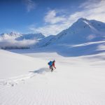
We were on the plane to Qikitajuaq and about to embark on the trip of a lifetime! The flight from Pangnirtung to Qikitarjuaq was phenomenal. We flew right over the Pass where we would be spending the next nine days. The peaks surrounding it were beyond impressive, especially since they were accompanied by massive glaciers that wove between them and merged into each other like some ancient icy highway interchange. If we followed these glaciers up their ice would eventually rise above these peaks, blanketing them in a six thousand square kilometres prison of ice called the Penny Ice Cap. Being able to enjoy the incredible views of this end of Baffin Island from the air turbo charged our excitement about the trip!

Even though it took way more time to get on the trail than we hoped, and we had to go through the hassle of extending our trip with our families, work, and airlines, it was all easily forgotten once we were on a boat headed towards Akshayuk Pass. Billy Arnaquq, a local outfitter, took us on a spectacular eighty five kilometre journey down the North Pang Fiord, where the evidence and power of the ice that carved it still seemed fresh. During our boat ride he shared stories of narwal, walrus, polar bears, hunting, fishing, his community, this land he loves, and how the land has been affected by climate change. As we continued up the fiord towards our destination the towering cliffs and mountains rose dramatically out the bright blue arctic water, that was decorated with countless icebergs. I’m not sure any of us anticipated how spectacular this part of our journey would be!

Day 1
- Distance: 13.7km
- Weather: Sunny, 2-8°C
- Camp: Near the Owl river emergency shelter; 20W 426400 E, 7420200 N, 120m
- Significant River Crossings: Owl River tributary, Unnamed River before the Owl river shelter
- Weather: Sunny 13C
We were joyfully hooting and hollering after we said goodbye to Billy as we finally arrived at the beginning of our trek across this rugged landscape. As the boat disappeared into the distance, we were quickly overwhelmed with where we now stood. We were all alone, in this huge landscape that was shared more commonly with polar bears than people! With so much anticipation leading up to this moment, we hoisted our seventy-five pound packs onto our backs and took our first steps on what would now be a nine day journey through one of the most spectacular landscapes on earth.

With no trail on the north end of the pass, the tundra—although it looked beautiful with its many wildflowers, lichens, short grasses, and moss—was an energy sucking beast! With every step, our feet were engulfed by the soft ground as we sunk six to twelve inches. Even though this terrain was more exhausting than its “Sound of Music” appearance would have led us to believe, we needed push on and get inland. Polar bears tend to hang out and forage near the coast and as much as we would have loved to see one from the boat, we weren’t overly excited about having an encounter with one on land.

We were aware that there would be several river crossings in cold glacial water, but we didn’t realize how challenging some of these would be. I was comfortable with rivers, having taken several swift water rescue courses in addition to significant experience in and on rivers for both work and play, but these arctic rivers had some additional challenges we needed to adapt too. Many of the rivers looked like chocolate milk with all the glacial till and mud that was suspended in it. We didn’t have the benefit of being able to see what was under the water which forced us to read the hydraulics of the river to determine the least dangerous point to cross.
We knew the water was going to be cold, but this water was seriously COLD! We all had high quality water shoes with good grip for the crossings. However, I think we would all agree that the top piece of gear we wish we had packed would have been neoprene socks for inside these shoes to reduce the severe bite of the icy water. A number of these rivers took significant time to cross, as we had to work as a team, deciding on the safest places to cross, and bracing each other against the flow of larger rivers. Additionally, these rivers were rarely one single channel, they were very braided, greatly extending our exposure to the chilly glacial meltwater. I still remember the expressions of pain and surprise on Chris and Jared’s faces as we came to an island in the middle of our first river crossing! It was extremely painful but humorous as we clumsily stumbled around on our frozen feet that felt more like a set of hooves.
Starting our trip a few weeks after the summer solstice gave us the pleasure of not having any light-related time constraints. We enjoyed twenty-four hours of light where the sun would only dip behind the steep mountains for a few hours per day. Starting at 4:30pm with unlimited light, we were able to travel fifteen kilometres over that foot eating terrain, amongst the swarming mosquitoes, and through two ice cold river crossings before we set up camp at 11:30pm near the Owl River shelter. There are small emergency shelters scattered throughout the pass to use in emergencies such as waiting out a hungry polar bear, protecting yourself from the extreme cold, or hiding from from 175 km/hr winds that frequent this pass!

We enjoyed setting up camp, eating food, and toasting a drink from one of our flasks as we soaked up the views and settled in for our first night. We were in awe as the sun set in the northwest, filling that end of the sky with its golden light, but instead of it fading into night, the golden light circled around to the northern sky, followed by the northeastern sky before it started to rise above the mountains again! Chris Kimmel, being an adventure photographer, was ecstatic about the consecutive golden hour(s) of great light that you get when the sky never goes dark. Just before the sun was about to rise above the mountains again, we flopped into bed and passed out at 1:30 am after a very long day starting in Iqaluit at 5:40am the previous morning.
Day 2
- Distance: 16.4km
- Weather: Mix of sun and cloud, 6-12°C
- Camp: Near the June valley emergency shelter; 20W 425517 E, 7406156 N, 201m
- Significant River Crossings: None
Without the worry of losing light later in the day, it was nice to be able to have a relaxing morning at camp. When we woke up the sky looked unsettled, there was moderate winds and the temperature was around 6°C. Around 11:00am, it started to drizzle, which got us packing up camp in record time. Thankfully this was short lived; the rain had stopped by the time we started putting some kilometres behind us in more soft, energy-draining terrain. We hiked into a strong headwind all day, which slowed our pace, but kept the ravenous mosquitos at bay—a welcome change from the previous day. Looking south down the pass in the direction we were headed, the weather continued to look unsettled all day. We saw many dark ominous clouds raining down on the route that lay ahead of us. However, there was a distinct line of clouds above us giving way to beautiful blue sky behind us that seemed to fight back these dark clouds at the same pace that we traveled!

One thing we quickly realized about hiking in the tree-free arctic is how hard it is to judge distance and size. There were times we were looking at a feature like one of the many gigantic moraines that stretched down into, and sometimes across the valley, thinking we would be there in a half an hour. However, without trees as a reference point to give perspective on distance and height, we would find that same moraine we had spotted earlier still ahead of us a couple hours later! We had some laughs and grumbles about this at times. Similarly, the peaks and cliffs we were hiking beneath were way more impressive than anticipated. I think we may have just assumed the size of many of these based on the pictures we saw. We remembered reading how the north end of the trail was not near as impressive as the south. This was both exciting and hard to imagine at this point given how impressed we were with the north.
Early that evening, we reached the June Lake Shelter where we set up camp. It was a spectacular scene. The Owl River was flowing in front of us and beyond that was a towering 1200m unnamed smooth granite face. We had hopes of playing cards that night, but our bodies did not allow it. We were exhausted and passed out quickly after eating dinner.

Day 3
- Distance: 17.3km
- Weather: Sun, 6-21°C
- Camp: Dried lake bed on the Hwy. Glacier terminal moraine; 20W 411675 E, 7398699 N, 315m
- Significant River Crossings: Rundle River
After surviving two significant down pours overnight in our Nemo tent that easily managed to keep us dry and comfortable, we all got baked out of the tent as the sun’s intensity grew. We were all pretty stoked to wake up to the brilliant blue sky, sunshine, and towering peaks looking even larger in the direction we were headed. As the day progressed temperatures climbed to a shocking 21°C and the rivers surged with new melt water. This would turn out to be our warmest day in the Arctic!

We had new excitement ahead of us. In the distance we could see the unmistakable form of Mt. Asgard. It didn’t look real. It was a massive cylindrical shaped peak with a flat top that demanded a weighty presence in the landscape as it rose over 2000m! None of us have ever seen a peak quite like this. It looked like we were in some CGI created landscape.
As we approached the Glacier Lake shelter, we discussed if we should set up camp and rest our sore feet and tired bodies or if we should get wet and freeze our feet once more in an attempt to cross the Rundle River, which would be the most challenging river crossing we had come across so far. As much as we would have loved to set up camp we thought we should give the river crossing a try. If we waited until the next day the flow would likely be higher from the increasing intensity of the sun.
As we crossed the first braid of the river with our large packs we quickly understood that this was going to be much more of a challenge than the previous rivers. We needed a new plan; we could not cross it safely as individuals. We ended up assembling the “tripod” for the first time. The “tripod” consisted of one person in the front facing upstream breaking the flow and the other two behind standing shoulder to shoulder supporting the guy in front. Even while working together to cross the second braid of the river, we barely made it, as the icy swift flow pushed up above our waists and rocks shifted under our feet, almost putting us under. Thankfully, our tripod worked in providing the additional support that we needed for anyone who became unstable. With several more braids of the Rundle River to cross we were able to work on perfecting this method, which was used in many of the crossings still ahead of us.

We found it challenging, terrifying, and fun all at the same time; trying to read the hydraulics of the river to find the best place to cross. It’s unfortunate we don’t have any photos of our “tripod” used to cross some of the more extreme rivers, but there was no way we were crossing some of those sections twice to retrieve a set camera. Cameras were sealed in dry bags and buried deep in our packs during these potentially dangerous river crossings.
With the fresh dose of adrenaline coursing through our veins, we had found new energy to push on a few more kilometres across a massive moraine that was on the other side of the river in search of a flat place to camp. This moraine was a whole new challenge as we scrambled over and around loose rocks and giant boulders. However, the solid ground was much preferred over the soft tundra behind us. We eventually found an awesome place to camp in the middle of the moraine on a small dried up lake bed, complete with epic views of Mt. Asgard.
Day 4
- Distance: 12.1km
- Weather: Sun, 6-14°C
- Camp: Turner Glacier, Across from Parade Glacier; 20W 402055 E, 7398108 N, 820m
- Significant River Crossings: None, we avoided the Turner River by traveling on the glacier
We were filled with disbelief as we woke to another spectacular blue sky. What a privilege it was to spend another day in such a beautiful place with such perfect weather. This was especially true since we knew the weather in the Arctic could be a very, very different beast. We read in one of the emergency shelters log books that a group spent four weeks in the pass and had rain, snow, fog and/or wind pretty much the entire time!
Today was the day we were hoping to head up on the Turner Glacier and camp beneath Mt. Asgard. As we continued to cross this enormous moraine that never seemed to end, we came across a brilliant blue lake. This lake was especially breathtaking against the lunar-like landscape of the moraine that surrounded it and distant treeless peaks.

After eight kilometres and another intense river crossing, we finally reached the base of the Turner Glacier. We found a medial moraine on the glacier which allowed us to avoid the potentially unstable sections of the glacier, where the Turner River was ripping through the ice as it searched for freedom from its glacial prison. We had read that most of the moraines in this area were ice cored. This was clearly seen as we stepped up onto this moraine. Underneath all the rocks and sand was very slick ice. Thankfully, we made it through the steep section to where it levelled out and travel was slightly easier. In hindsight, it may have been smart to put on our crampons on here for extra assurance in our steps.

After traveling up this moraine for several kilometres, we stepped off onto the glacier and continued up. The views were becoming increasingly spectacular as the low light began to illuminate many wispy clouds, including the ones we could see slowly swirling around Mt. Asgard. This added a whole new dynamic to this incredible skyscraper, along with many of the other surrounding peaks. The melt water was not only running underneath the glacier but on top of it now too! The water helped show off the brilliant blue colour of the glacial ice as countless streams, both large and small, braided their way down to the valley, occasionally vanishing into some deep crevasse. In the distance, like a shark fin rising out of water, Mt. Loki slowly came into view. I had forgotten that we would see this peak on the glacier, but it was an incredible surprise that made the landscape feel even more surreal!

We eventually found a flattish, smoothish, place to set up our tent. This wasn’t our most level or smooth tent location on the trip, but it was worth it to be on the glacier for a night. We all probably could have slept anywhere at this point anyway. Before we passed out, we enjoyed the never ending evening light, some good food, great whiskey, and a fire we lit on the glacier with the excessive volume of gas we had brought. As we headed to bed, fog rolled in, blocking out any view. We realized that our good weather streak might finally be over. Our comfortable mats floated our worn out bodies above the rough edges of the glacier and our fluffy sleeping bags kept us warm, as we wondered if these less than ideal conditions would prevent us from continuing our traverse over the Parade Glacier the next day. But that was a problem for future us.
Day 5
- Distance: 12.7km
- Weather: Sun 3-12°C
- Camp: Near the Summit Lake emergency shelter; 20W 401373 E, 7390134 N, 397m
- Significant River Crossings: Norman River. We avoided the Caribou River by traveling up the Turner Glacier
We woke up, fist pumping the air as the fog was just giving way to an incredibly blue sky overhead. Another weather lottery win!

After packing up camp, we pressed on, traversing the Turner Glacier and transitioning onto the much smaller Parade Glacier, with a headwall created by glacial recession visible in the distance. We were not sure we would be able to find a safe route up this headwall to gain the col and access the Parade Glacier on the other side. Even though there was some uncertainty with this route, we decided to take advantage of the fantastic day and press on, knowing that we would have to retrace our steps back down to the valley we came from the day before if we could not access the col.
Traveling up the Parade Glacier was amazing. It narrowed and steepened as we moved right beneath Mt. Asgard and many other impressive peaks. These towers of granite stretched up above the ice, towards the bright blue sky, with impressive unnamed glaciers that seemed to cling impossibly onto the steep faces above us. As we approached the headwall that we had hoped to ascend, we realized how much the glacier had receded and how large this wall was. Our hopes of gaining the col were shrinking, but we held onto hope as we continued toward a feature in the headwall we thought we could climb. On the way, we spotted narrow and very steep finger of the glacier in the distance that extended up, away from the Parade Glacier, on the right side of the headwall. Unfortunately, we thought it looked too steep for us to climb, especially with the limited ice climbing gear we had, so we were hoping there would be a decent route up the headwall instead.

As we approached the col, things were not looking good. The one spot on the headwall that looked hopeful from a distance was a definite no go, as we saw a number of large rocks fall down where we had hoped to climb. It seemed like we were out of options. The only thing we thought we would check before we turned around was to head towards the base of the steep section of glacier we had seen from a distance to check it out a little closer. It was definitely steep, about 50 to 60 degrees, with a few small streams, like strings of spaghetti flowing down the icy slope.
Though it looked daunting from a distance, as we got closer we started to get excited, discussing how we could piece together some of the small variations in the glaciers surface to make a route up possible. We had brought two ice screws, not with the intent of climbing anything with them, but more as a contingency. However, we wanted to get to the other side of Parade Glacier. We thought, with some creative placement and movement of the ice screws, we could use them as a couple points of security to attach our rope to, as we carefully moved up the 200m incline. We were all thankful for the added security that our crampons, ice axe, rope, and ice screws provided as we navigated up the steep icy slope, stepping over a few glacial melt streams on the way. Near the top, we all hoped that the other side would be navigable. Up until now, we had only seen topographic maps and blurry photos of the glacier. We were uncertain if traveling down this side of the glacier would be possible, or if we would have to go back down the way we came. Thankfully it was!


Akshayak Pass 2019 – © Christopher Kimmel
Before heading down toward the Caribou Glacier, we enjoyed lunch, refuelling our bodies, and taking a well deserved break. We were surrounded by a cirque of impressive peaks and glaciers that extended down towards the valley in every direction we looked. After our short break, we began our descent, enjoying all the new peaks, ridges, and hanging glaciers above and below us that were coming into view.

We soon merged off of the Parade Glacier, onto the Caribou Glacier, and headed back toward Akshayuk Pass. The last several kilometres near the terminus of the Caribou Glacier were extra challenging. There were lots of loose rocks and boulders that caused a couple slips and close calls, as they shifted under our weight and occasionally rolled down the icy slope. Eventually, we had relief from this terrain when we made it to stable ground and finally arrived at the Summit Lake emergency shelter at 10:00 PM. It was a bit of a shock to meet two climbers, who were also camping near the shelter. These were the first people we had seen since we said goodbye to Billy, when he dropped us off on the north end of the pass!

Day 6
- Distance: 10.7km
- Weather: Sun, 5-11°C
- Camp: Near the Thor emergency shelter; 20W 396465 E, 7383751 N, 162m
- Significant River Crossings: Half Hour Creek
Today we had Mt. Thor in our sights! This peak is truly impressive and had us all captive to its wonder! It pierces the sky at 1675 metres, which isn’t even the impressive part. It has an unbelievable 1250 metre cliff face, which makes it the tallest vertical cliff face on Earth! Not only that, a good portion of this cliff face overhangs the valley by 15 degrees! This view we were all now captivated by was the first image I saw of Akshayuk Pass, over a decade ago when this dream first took ahold of me! It was pretty energizing and surreal to actually be in this spot.

However, this feeling was quickly replaced with thumping hearts and nervousness, as we attempted to cross the raging Half Hour Creek. We explored a couple hundred metres of this unforgiving flow of water, looking for a place to cross. As we searched for a crossing, we witnessed chunks of ice that had been ripped from its glacial mother against its will, floating by us in a torrent of chocolatey water and boulders shifting and knocking together under the water’s force. Our prospects of crossing were not looking good. We attempted crossing several smaller braids of the creek, but were unsuccessful at making it all the way across. It was mid day, the flow was way too high, and consequences grim, if not fatal, if we tried to cross the largest and final braid of the creek. We made the hard decision to drop our bags and wait it out for at least ten to twelve hours, when the flow would hopefully be lower. After we dropped our bags, two of us decided to do some exploring and climb up beside a very steep portion of the creek. We couldn’t believe our luck! When we reached the top of this steep section, the river braided perfectly, right before it poured over the edge! It still looked like an intense crossing, but within the realm of possibility. We went back down to grab our bags, excited to share the good news. Thankfully, we managed to make it across using our perfected “tripod” technique once again.
We eventually made it to our camp spot, which was directly beneath Thor’s incredible face! We met a climbing group of four and enjoyed sharing some food and stories as we relaxed in this incredible place. Originally, we had hoped to spend two nights here and climb Mt. Thor. However, with our trip being shortened due to delays, we regrettably had to push on the next day.
Day 7
- Distance: 14.0km
- Weather: Sun, 5-13°C
- Camp: On a large beach North of Crater Lake; 20W 387964 E 7375545 N, 60m
- Significant River Crossings: Schwartzenbach River and Crater Lake Outflow
After packing up our camp at Thor, we felt like we had passed some sort of checkpoint in the pass. We had only twenty-four kilometres and two more nights still ahead of us. There was a tangible relief, knowing that most of the major river crossings were behind us, along with many other of the unknowns we faced on the glacier and the northern part of the pass. The biggest plus to this was that there was a ton of snack food that no longer had to be rationed as carefully!


Akshayak Pass 2019 – © Christopher Kimmel
Throughout the pass, it took a great deal of self control to not devour all the bars, jerky, dark chocolate, moon cheese, etc. all at once—especially when there were two other sets of eyes looking at your snack stash as well. Someone else always seemed to have something tastier than what was in front of you. That being said, we did a pretty good job of sharing snack food and meals throughout the trip to increase the variety of what we were eating. Now that we had passed our camp at Mt. Thor, the food stores opened right up! Particularly when we found out that one member, who won’t be named for his crime, was found to be holding out on us with a stack of energy gummies he had left. We gladly helped him eat these over the next several days, as we didn’t want to discover that we needlessly carried even a crumb of food through the pass.
This part of the pass had a decently established footbed. However, sections were washed out and massive moraines stretched into the valley, forcing you to resort to a “choose your own adventure” sort of route. There were some pretty beautiful waterfalls along this section of the trail. This included Schwartzenbach Falls and an unnamed creek that cascaded down the mountain. This unnamed creek was especially captivating, as it divided up into many separate waterfalls on its way down the jagged slope, and the sun was hanging low and hitting some of the falls at just the right angle to illuminate them, like waterfalls of fire.
That night, we camped on the north side of the Crater Lake on a beautiful sandy beach. We kicked off our boots and hobbled around in the sand, on our raw feet and sore tendons, and chucked a frisbee around. It was glorious!

Day 8
- Distance: 8.7km
- Weather: Sun, 6-13°C
- Camp: On a small knoll above the Ulu emergency shelter; 20W 388554 E, 7368025 N, 74m
- Significant River Crossings: None
Our last full day on the trail! At this point, the cravings for food off the trail, getting home, and seeing our wives and kids again were at an all time high. Even though we were looking forward to being done, I think we all knew we would soon long to be back in this pass. We weren’t wrong about that. As I am writing this right now, I can think of several times I have wished we were back there, or had more time. It was a pretty spectacular trip, to one of the most remote, rugged, and raw places I’ve ever been.

With our minds on char burgers, french fries, and beer, we continued on over moderate terrain, enjoying more great weather. We arrived at the UIu shelter, where a group of six hikers we had met earlier that day had set up camp. With some energy to spare, we took a short steep climb up to a bluff directly above the shelter to set up camp and enjoy our last night from an elevated vantage point. It was time to get rid of everything we didn’t need to take back with us. We devoured every last crumb, minus a couple bars and energy gummies we were saving for the next day, and burnt off most of our remaining gas in spectacular fashion!

Day 9
- Distance: 4.1km
- Weather: Overcast and raining, 2-7°C
- Significant River Crossings: None
Our streak of winning the weather lottery was over. All the peaks were gone, it was raining, and it was cold. We kind of had a feeling this might happen on our last day, just so we would know what the trip could have been like had the weather been different. Thankfully, we had plenty of sunshine and great weather that allowed us to see all the peaks and glaciers up to this point. We were not going to complain about the remaining four kilometers in the rain!
Previously, we attempted to radio Parks Canada to confirm our boat pick-up time and location from the emergency radios in the Thor and Ulu shelter with no luck. We also tried using our inReach Mini to text the outfitter. Unfortunately, there was no response there as well. This was not by any fault of the inReach; it turned out the guy just rarely checked his texts.
In total, we saw only fourteen people while we were in the pass, and they were all in the last few days. One of the groups was a group of six that was camping down below us near the Ulu shelter. Thankfully, they were generous enough to let us use their satellite phone, and after several attempts, we were finally able to get ahold of the outfitter and confirm our pick up.
Peter Kilabuk, our outfitter on the southern side of the pass was on time and got us to Pangnirtung safe after a thirty-five kilometre boat ride through the rain on rough water. We stopped at the Parks Canada office to let them know we were out of the pass and found out that all flights were cancelled that day due to weather. This was devastating, but not as devastating as it was to be stuck in Pangnirtung for an additional two days afterwards, from more flight related issues. We were done. Pangnirtung is a dry community of 1500 where the only restaurant they had was a KFC with a significantly reduced menu. We ate KFC for two consecutive days and thought we were going to barf—not exactly the food we were dreaming of when we were in the Pass. Under different circumstances and better weather, Pangnirtung would be a very interesting place to explore. But with low fog, the headache of rearranging work schedules back home, and telling our families we were delayed again, and again, it was not the place we wanted to be.

Despite all the headaches of northern travel we encountered, we eventually made it home and still managed to find our celebratory beers and Arctic char on the way, during our 24hr layover in Iqaluit. The trip cost us extra days away from our families, a bit more money, and a few extra days off work, but this was all worth it and soon forgotten as we started looking back on photos, sharing stories, and dreaming of going back some day. Maybe on skis next time…


Below is the gear we brought through the Akshayuk pass. We started with 75lb packs and we estimated that by the end they were about 60lbs.


Group Gear
Cooking & Drinking
- MSR XL Autoflow water filter
- MSR Whisperlite stove
- MSR Fuel – 30 oz bottle
- MSR stainless steel pot
- MSR Stove repair kit
- Flasks
Camp
Other
- Zip ties
- Tenacious tape
- Sunscreen
- Bug repellant
- Leatherman
Safety & Navigation
- Beofeng radios
- First aid kit
- SOL Emergency Bivvy
- Waterproof matches
- Akshayuk Pass map
- Garmin inReach Mini
- Cell phones
Technical Gear
- Beal 45m half rope
- Petzl ice screws
- Petzl PMPs
- Black Diamond webbing
- Black Diamond slings
- Black Diamond nuts
- Camp tri-cams
Personal Gear
Clothing
- Mammut GTX jacket
- Mont-Bell rain pants
- Arc’teryx softshell pants
- Scarpa mountaineering boots
- Arc’teryx down jacket
- Black Diamond gaiters
- Buff touque
- Buff neck tube
- Arc’teryx hat
- Petzl gloves
- Solomon water shoes
- T-shirts
- Long-sleeve shirt
- Shorts
- Mammut fleece hoody/midlayer
- Saxx boxers
- Wool socks
- Down booties
- Sunglasses and strap
- Camp towel
Other
- Mammut Trion Spine 75 L pack
- Marmot 0C down sleeping bag
- Thermarest Neoair sleeping mat
- Foam butt pad
- Phone case/bag
- Camera
- Petzl Actik headlamp
- 20L Arc’teryx summit pack
- Goal Zero solar charger
- Soap
- Toilet paper roll
- Hand sanitizer
About the Authors

Christopher Kimmel is an outdoor adventure and lifestyle photographer who lives with his wife and two children just outside of Vancouver, Canada. When not hard at work planning for the local Regional Parks Department, you can find Christopher photographing and exploring the forests, canyons and mountains of southwest British Columbia and beyond with his family and friends.
Through his unique visual storytelling style, Christopher aims to share the wild-and-free feelings of exploring nature to his audience. His work draws attention to the interconnectedness of humans and their natural environment, and conveys the importance of experiencing and protecting the outdoors for generations to come. Always seeking out the remote and untouched destinations around him, Christopher continues to push the limits of outdoor adventure photography with his creative eye and compositions. His photography is regularly published by National Geographic, Backpacker Magazine, and Lonely Planet, among many others. You can see more of his work on his website (www.alpineedge.ca) or find him on Instagram (@alpineedge).

David Wilson is a firefighter and a Search and Rescue Volunteer and loves sharing his passion for the outdoors, adventure, and the environment with others. Exploring wild outdoor places, in terrain much bigger than himself and everyday life, allows him to push his body and mind as he builds stories and memories with others.
David grew up in Alberta with the Rocky Mountains as his playground and throughout the last decade has made the Coast Mountains his local stomping grounds. Now living in Squamish, BC, it is not uncommon to find him backcountry skiing, mountain biking, rock climbing, mountaineering, canyoning, or immersed in some other outdoor adventure. David and his wife now have a 2 year old, which has been the start of another grand adventure! They have loved introducing him to their world, taking their little man cub on many of these same adventures, or maybe just throwing rocks in a stream…
Follow David on Instagram @_dawilson_ to see what adventure he is on next!

Jared Rayner is a husband, adventure dad, and entrepreneur from Alberta, Canada. Originally from Vancouver Island, British Columbia, Jared spent his childhood years camping, hiking, dirt biking, or at any activity that would allow him to be in the outdoors. Being homeschooled up until high school allowed him the extra time, that most kids only dreamt of having, to imagine, play, and explore in the backcountry.
Some of the dreams realized have been a 4000km bike ride from British Columbia to Mexico in support of the Children’s Hospital, leading a team to Africa to work in an orphanage, camping across New Zealand, and hiking the Akshayuk Pass on Baffin Island. Even though no longer a kid, Jared’s “never grow up and dream until you die” attitude has kept him searching for opportunity, in life and business, to take risks for even greater experiences. You can find more of his adventures and shenanigans on Instagram (@jared.rayner).

16 Comments
We ran into these guys near the end of the trail. Excellent photos.
Hi Andy, that is awesome! I bet you also had a great adventure!
Hello Guys
Wondering if any of you still live on the Island.
I could really use some instructions on the river crossings and was wondering if you know of any courses.
Or could we meet and go over the itinerary?
We plan to just do the lower portion up to Summit lake if possible.
Thank you
Carmen
Hi Carmen,
None of us live on the Island, sorry.
I would recommend taking a swift water rescue course and talk to them ahead of time and at the start of the course about your objectives/ what you are hoping to get out of the course. They should be able to accommodate and direct some extra focus toward river crossings.
There are a number of companies that offer different courses. I live in Squamish, BC and I took a swift water rescue course several years ago through Raven Rescue.
I’m happy to look over your itinerary if you like. Feel free to message me on Instagram. (My handle is in my bio above)
How did you guys deal with storing your food on the trail? There are obviously no trees on the trail from the pictures.
Hi Mel,
Sorry I missed responding to this earlier. When we were camped near an emergency shelter, we would use it to store our food (which was mostly in sealed packages and in a dry bag). When we were not by a emergency shelter the lack of trees definitely did make safe food storage more of a challenge. In these cases our dry bags were stored away from the tent. If possible we would try to protect it under large rocks or hanging it off a massive boulder. Although there are polar bears in the area, they are typically by the coast. So rodents we’re our main worry once inland.
Hi David, we’re planning on a similar trip in summer 2022. Our main goal is to climb mount Thor. We will be coming from Pang. Still not sure on which side of the Weasel River we will hike (east (or Thor side) or west (the easiest side, I think)
From what I understand, you did plan on climbing mount Thor too. So I have a question for you : from what you have seen, is it possible (and safe) to cross the Weasel River at some point near mount Thor? Where and how did you plan to cross?
Thanks!
Very exciting! It’s definitely an amazing place that I’d love to go back to someday. We did hope and plan to climb Mt. Thor but due to unforeseen delays and complications getting there we lost the needed time to climb it. There wasn’t many disappointments on the trip but that was one, so I hope you guys can find a way to make it work!!
The weasel river would not be easy to cross at most locations. Whether its safe, highly depends on conditions, The melt water can fluctuate a lot depending on weather, when we were there it was relatively warm and a lot of the river looked pretty deep and roudy! A packraft would be my top choice to get across the river to access Thor. You then would be able to use it to make your way back down towards Pang if conditions permit (it can get pretty wild).
As we were planning, you can try to find a braided section to attempt a crossing but as I mentioned, there are no guarantees there. The crossings, even of the tributaries, can be pretty intense. As a last resort, we would have possibly attempted swimming across a still section of the river or narrow spot at a lake but this would have been pretty miserable and probably not recommended.
The safest bet is probably to hike up the Eastern side if Thor is the main goal. As you have heard, it likely is a rougher/non existent trail, especially past the windy lake shelter. I wish they still had the bridge! But unfortunately I heard it had been washed out several times.
Hope you have an awesome trip and don’t hesitate to reach out if you have more questions.
Thanks a lot for your answer David. As our project is taking more and more its shape, we end up planning on an approach via the Eastern side of the Weasel, so no crossing/swimming/paddling across the river!
Again, thanks for your time!
No problem at all Pierre-Oliver. That’s probably a good plan. Hope it’s an epic trip!
Thanks for a great trial report! We are planning a trip this August, half way up the pass from the south. I have a question: I can’t bring my backpacking stove because they won’t allow it on the airplane. Are backpacking stoves available for purchase in Pang?
Hi Harris,
Glad you found the trip report!
We brought a whisper light international (similar to VPO’s XGK EX stove, which actually looks a little better than the one we had). You’re allowed to bring these stoves on planes as long as the fuel canisters are empty clean (make sure they do not smell like gas).
The nice thing about the international and XGK EX stoves is you can burn many different types of fuel and they’re fairly easy to repair (I would also purchase a repair kit). We did find white gas up there but we weren’t stressed if we didn’t as I’ve burned regular gas from the gas station in these stoves many times.
I’m not sure I would make the gamble of buying a stove up there. If you were even able to find one, that would work for this sort of trip the price would be astronomical.
Hope it’s an awesome trip!
Dave
Hi David
We are not planning on climbing but are hiking the pass from north to south. We would like to travel the route up the Turner, across Parade and down Caribou Glaciers. I notice in your images you are roped only part of the time. Was being roped necessary or could you get away without if not planning for any climbing?
thanks
Hi Bernie,
Sounds like an awesome trip! It’s a pretty incredible place.
It’s hard to answer your question concretely without knowing knowing your comfort level, skill level, or the condition that the glacier is in now. Its possible if the glacier has continued to recede that the headwall extends all the way across that end of the valley.
When we were there, the glacier was free of snow making any hazardous crevasses easy to avoid. We only roped up at the end of Parade glacier as it approached the col because of how steep and icy it was. At the time there was no huge hazards (cliff, crevasse, etc.) that would cause a major injury or death if we were to fall. Since this part of the glacier was quite steep and icy and we thought it would be best to rope up to reduce the chances of getting banged up out there if there was a fall.
If you attempt it I would leave extra time so that you can turn back if needed. You don’t want to make unsafe decisions because of time pressure. hope that helps you make your decision.
Hey David
Great trip report! Thanks for it.
I’m considering doing the Pang to Mt Thor and back trip this summer with my adult son. I have a fair bit of backpacking experience but none in the arctic besides Iceland. I’m not sure what to make of the polar bear warnings from Parks Canada. I guess that they are doing their due diligence by putting some fear into you but from what I’ve seen on any trip reports once you get away from the coast, the chance of an encounter is greatly reduced. Beyond having bangers and spray (if available) and being vigilant, is there anything to worry about? Do hikers use perimeter fences? I’m guessing not.
Thanks again,
Malcolm
Hi Malcolm,
Glad you found and enjoyed the trip report! I think what you have heard about polar bears is pretty similar to our understanding. Moving away from the coast should decrease your risk. I never heard of anyone using perimeter fences up there but we were able to source some bear spray (Not cheap, but we sold it at a reduced cost to our boat shuttle driver on the way back). Other than that we just practiced general bear safety.
We never saw any polar bears or evidence of them. I think they were still all out on the ice. I would think that the polar bear risk is pretty dependent on how the ice is holding up. If you go later in the summer or if it’s an earlier than normal melt it may push the bears onto land and extra caution may be needed.
Hope your trip is amazing!