
- Account
-
- NEW ARRIVALS
- Men
-

Core Climbing Apparel from prAna
Shop Now »
- Women
-

Patagonia Offers Versatility and Comfort for all your Adventures
Browse Patagonia »
- Kids
- Gear
- Snow Sports
-
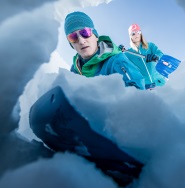
Stay Safe in the Backcountry
Shop Ortovox»
- Paddle Sports
-

Santa Knows How to Enjoy His Off-Season
Shop Red Paddle »
- DEALS
Backroad MapbooksNelson Topo Map - Waterproof

This recreation topographic map for the Nelson area highlights all the logging and resource roads, multi-use trails for hikers, mountain bikers, horseback riders, cross-country skiers and snowshoers, motorized trails for ATVers and snowmobiles, fishing lakes and rivers, recreation areas, campgrounds, day-use areas, viewpoints, backcountry campsites, backcountry huts and cabins and more. No other map for the area provides you with this level of recreational or topographic detail. Special features include private land, labelled fish species and countless roads, trails and recreational Points of Interest. Covering 1,950 km2 (753 mi2), this 1:65,000 scale map measures 38 x 51 km (23.5 x 32 mi). This map includes Nelson, Kootenay River, West Arm, Morning Mtn, Kokanee Creek Prov Park, West Arm Prov Park, Kokanee Glacier Prov Park, Valhalla Prov Park, Slocan Lake, Slocan River and more!
This map also covers the following Wildlife Management Units: WMU 4-16 Kootenay, WMU 4-17 Kootenay, WMU 4-18 Kootenay, WMU 4-7 Kootenay, WMU 4-8 Kootenay.
This map also covers the following Wildlife Management Units: WMU 4-16 Kootenay, WMU 4-17 Kootenay, WMU 4-18 Kootenay, WMU 4-7 Kootenay, WMU 4-8 Kootenay.
Backroad Mapbooks
"http://schema.org/NewCondition"
Out Of Stock
Out of Stock: Nelson Topo Map - Waterproof

Uh-oh! We’re sorry, but This product is no longer in stock.
But don’t worry! We have lots of other great products available to fit your needs. Browse Similar Products


Sorry, the real-time inventory lookup is not available at this time.
Sorry, the colour and size you selected is not available.
Colour & size selection available at: