
- Account
-
- NEW ARRIVALS
- Men
-

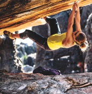
Core Climbing Apparel from prAna
Shop Now »
- Women
-
Patagonia Offers Versatility and Comfort for all your Adventures
Browse Patagonia »
- Kids
- Gear
- Snow Sports
-
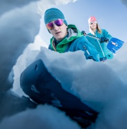
Stay Safe in the Backcountry
Shop Ortovox»
- Paddle Sports
-

Santa Knows How to Enjoy His Off-Season
Shop Red Paddle »
- DEALS
This recreation topographic map for the Stagleap Provincial Park area highlights all the logging and resource roads, multi-use trails for hikers, mountain bikers, horseback riders, cross-country skiers and snowshoers, motorized trails for ATVers and snowmobiles, fishing lakes and rivers, recreation areas, campgrounds, day-use areas, viewpoints, backcountry campsites, backcountry huts and cabins and more. No other map for the area provides you with this level of recreational or topographic detail. Special features include private land, labelled fish species and countless roads, trails and recreational Points of Interest. Covering 1,950 km2 (753 mi2), this 1:65,000 scale map measures 38 x 51 km (23.5 x 32 mi). This map includes Kootenay Lake, Darkwoods National Wildlife Area, Wynndel, Stagleap Prov Park, Leach Lake, Six Mile Slough, Dodge Creek, Duck Lake, Drewry, Kuskonook and more!
* Dimensions: 60 x 80 cm / 24 x 37 inches
* Map Scale: 1:65,000
* Map Features: Attractions, ATVing, Camping, Fishing, Hiking, Hunting, Paddling, Skiing, Snowmobiling, Hydrology, logging and industry roads
Features:
*


How Adventure Bucks Work
Earn Adventure Bucks every time you make a purchase*! Even 'on sale' items, in-store or online at VPO.ca. Each Adventure Buck is worth $1, so figure out what you want to buy!
You can redeem your Adventure Bucks at anytime:
- InStore: Ask the staff to apply your Bucks to your purchase.
- Online: Enter the amount of Bucks you wish to redeem in the Payment tab to apply them to your online order.
- *Arc'teryx items are excluded
Shipping Information
We Ship Anywhere Within Canada
Signature Required & Faster Shipping Options
All parcels are shipped ground with a signature required. If you want your order quicker, give us a call at 1-800-SHOP-VPO for a quote. Prices are in Canadian dollars. We will ship your order via Purolator Ground or Canada Post Regular Parcel . If you prefer one method over another, please make note in the notes/delivery instructions when you checkout.
Free Shipping
FREE shipping on orders totaling $49 or more before taxes.
NOTICE: THIS ITEM WILL BE DELAYED BY 5-12 BUSINESS DAYS.
| Destination | Estimated Arrival |
| Western Canada | 5-15 business days |
| Central Canada | 7-17 business days |
| Eastern Canada | 9-21 business days |
* We use Purolator for majority of our shipments. If you live in a rural area, Northern Canada, the Maritimes, or we have to use Canada Post for delivery, please note that the estimated arrival time may be longer.
Oversized or Overweight Item
This item is subject to a shipping surcharge
Unfortunately due to the size or weight of this item, we are required to apply a shipping surcharge when you order this item. To read our full shipping and freight policy, please click here.
Sorry, the real-time inventory lookup is not available at this time.
Sorry, the colour and size you selected is not available.
Colour & size selection available at: