
- Account
-
- NEW ARRIVALS
- Men
-

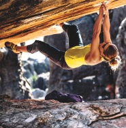
Core Climbing Apparel from prAna
Shop Now »
- Women
-
Patagonia Offers Versatility and Comfort for all your Adventures
Browse Patagonia »
- Kids
- Gear
- Snow Sports
-
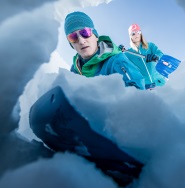
Stay Safe in the Backcountry
Shop Ortovox»
- Paddle Sports
-

Santa Knows How to Enjoy His Off-Season
Shop Red Paddle »
- DEALS
Backroad MapbooksAdventure Map - Red Deer to Nordegg - Alberta Foothills

This recreation topographic map for the Rocky Mountain Foothills around Rocky Mountain House and Red Deer highlights all the roads, fishing lakes & streams, front and backcountry campsites, paddling routes for canoeing and kayaking, wildlife viewing areas, multi-use trails for hiking, backcountry skiing, snowshoeing, mountain biking, horseback riding & more. Covering 1,950 km2 (753 mi2) using 1:50,000 scale water and road data, this map measures 38 x 51 km (24 x 32 mi), providing you with more topographic and recreational detail for the Nordegg to Lacombe and Olds area of Alberta than any other map on the market. Special features include private land and countless roads, trails and recreational Points of Interest. Included on this map are Red Deer, Rocky Mountain House, Caroline, Innisfail, Lacombe, Nordegg, Olds, Sundre, Sylvan Lake, Ya Ha Tinda Ranch and more!
The printed version of the map is displayed at 1:200,000 scale on 61 x 103 cm (24 x 40.5") paper. You can choose between having the map printed on regular water-resistant paper or a more durable waterproof synthetic. The Wall Maps have been customized to display nicely and fit into common picture frame sizes so you can hang on the cabin, home or workshop wall. They are available in three different sizes and come printed on the waterproof synthetic material.
The printed version of the map is displayed at 1:200,000 scale on 61 x 103 cm (24 x 40.5") paper. You can choose between having the map printed on regular water-resistant paper or a more durable waterproof synthetic. The Wall Maps have been customized to display nicely and fit into common picture frame sizes so you can hang on the cabin, home or workshop wall. They are available in three different sizes and come printed on the waterproof synthetic material.
Backroad Mapbooks
"http://schema.org/NewCondition"
Out Of Stock
Out of Stock: Adventure Map - Red Deer to Nordegg - Alberta Foothills

Uh-oh! We’re sorry, but This product is no longer in stock.
But don’t worry! We have lots of other great products available to fit your needs. Browse Similar Products


Sorry, the real-time inventory lookup is not available at this time.
Sorry, the colour and size you selected is not available.
Colour & size selection available at: